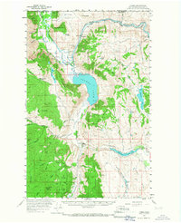
1956 Map of Loomis
USGS Topo · Published 1967About this map
The Similkameen River carves a deep valley through the northern Okanogan highlands in this mid-century survey, crossing the Canada United States border near Nighthawk. The landscape is a complex network of mining claims and rugged peaks, where the Great Northern railroad follows the river's path to serve the region's mineral wealth. Dozens of specific mines are documented, including the Golden Zone Mine and the Horn Silver Mine, illustrating the intense prospecting history along the slopes of Chopaka Mountain and Ellemeham Mtn.
Find a feature on this map
79 named features on this map. Tap any name to fly to it.
Don’t see what you’re looking for? This feature index may not catch every label — zoom into the map to look around manually.
Map Details
Editions of this 1956 Loomis Map
3 editions found
Other maps of this area

1902 · Osoyoos
USGS Topo · 1:125,000

1904 · Osoyoos
USGS Topo · 1:125,000

1906 · Chopaka
USGS Topo · 1:125,000

1954 · Okanogan
USGS Topo · 1:250,000

1956 · Loomis
USGS Topo · 1:62,500

1956 · Tiffany Mountain
USGS Topo · 1:62,500

1956 · Horseshoe Basin
USGS Topo · 1:62,500

1957 · Conconully
USGS Topo · 1:62,500

1957 · Tonasket
USGS Topo · 1:62,500

1957 · Oroville
USGS Topo · 1:62,500