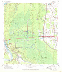
1968 Map of Lottie
USGS Topo · Published 1969About this map
The Atchafalaya River and the Morganza Floodway dominate this landscape in Pointe Coupee Parish during the late 1960s, illustrating the complex water management systems of the Atchafalaya Basin. The map details the intersection of industrial development and rural life, centered on the village of Lottie and the settlement of East Krotz Springs. Extensive energy infrastructure is evident throughout the terrain, particularly within the Lottie Oil and Gas Field and the Sherburne Gas and Oil Field, which are marked by numerous wells and pipelines crossing the swampy lowlands.
Find a feature on this map
38 named features on this map. Tap any name to fly to it.
Don’t see what you’re looking for? This feature index may not catch every label — zoom into the map to look around manually.
Map Details
Editions of this 1968 Lottie Map
2 editions found
Other maps of this area

1935 · Osca Bayou
USGS Topo · 1:62,500

1939 · Fordoche
USGS Topo · 1:62,500

1940 · Arnaudville
USGS Topo · 1:62,500

1953 · Maringouin
USGS Topo · 1:24,000

1954 · Fordoche
USGS Topo · 1:24,000

1954 · Baton Rouge
USGS Topo · 1:250,000

1955 · Osca Bayou
USGS Topo · 1:62,500

1955 · Fordoche
USGS Topo · 1:62,500

1956 · Baton Rouge
USGS Topo · 1:250,000
1959 · Osca Bayou
USGS Topo · 1:62,500