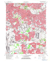
1982 Map of Louisville East
USGS Topo · Published 1983About this map
Louisville is shown during a period of significant suburban maturation, dominated by the branching forks of Beargrass Creek and a dense network of Catholic parish schools and historic cemeteries. The sprawling grounds of Cave Hill Cemetery and Calvary Cemetery anchor the older urban neighborhoods like German Town, while the southeastern expansion is defined by early subdivisions such as Audubon Park and Seneca Gardens. This survey captures the massive footprint of the region's transport hubs, from the Louisville and Nashville rail lines to the extensive airfield layouts of Standiford Field and Bowman Field. Educational and religious landmarks are exceptionally dense here, featuring dozens of sites like Atherton High Sch, St Michaels Church, and Resurrection Sch, which served the growing post-war residential tracts of Okolona and Newburg.
Find a feature on this map
111 named features on this map. Tap any name to fly to it.
Don’t see what you’re looking for? This feature index may not catch every label — zoom into the map to look around manually.
Map Details
Editions of this 1982 Louisville East Map
3 editions found
Other maps of this area

1905 · Prospect
USGS Topo · 1:62,500

1907 · Louisville
USGS Topo · 1:62,500

1909 · Kosmosdale
USGS Topo · 1:48,000

1912 · Prospect
USGS Topo · 1:62,500

1912 · Kosmosdale
USGS Topo · 1:62,500

1937 · Jeffersonville
USGS Topo · 1:24,000

1939 · New Albany
USGS Topo · 1:24,000

1946 · Jeffersonville
USGS Topo · 1:24,000

1946 · New Albany
USGS Topo · 1:24,000
1950 · New Albany
USGS Topo · 1:24,000