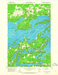
1959 Map of Lower Whitefish Lake
USGS Topo · Published 1966About this map
Lower Whitefish Lake serves as the central hub of this Crow Wing County landscape, recorded during a period of established lakeside settlement and recreational growth. This 1959 field-checked survey highlights a complex aquatic network where the Upper Whitefish Lake and Big Trout Lake connect through forested narrows. The map provides a detailed view of local life in the late 1950s, from the religious center of Our Lady of the Snows Chapel to the residential clusters at Manhattan Beach and Swanburg. Unusual local nomenclature like Hooligans Hole and Pecks Puddle appears alongside more formal boundaries of the Crow Wing State Forest. The inclusion of depth curves and soundings across major basins, including Rush Lake and Watertown Lake, offers a specialized glimpse into the underwater topography before modern developments altered these shorelines.
Find a feature on this map
54 named features on this map. Tap any name to fly to it.
Don’t see what you’re looking for? This feature index may not catch every label — zoom into the map to look around manually.
Map Details
Editions of this 1959 Lower Whitefish Lake Map
3 editions found
Other maps of this area

1953 · Brainerd
USGS Topo · 1:250,000

1957 · Brainerd
USGS Topo · 1:250,000

1958 · Brainerd
USGS Topo · 1:250,000

1959 · Trommald
USGS Topo · 1:24,000

1959 · Pelican Lake
USGS Topo · 1:24,000

1959 · Nisswa
USGS Topo · 1:24,000

1959 · Lower Whitefish Lake
USGS Topo · 1:24,000

1959 · Jenkins
USGS Topo · 1:24,000

1960 · Cross Lake
USGS Topo · 1:24,000

1965 · Brainerd
USGS Topo · 1:250,000
Featured Places
- Breezy Point, MN
- Fifty Lakes, MN
- Manhattan Beach, MN
- Golden Harbor Mobile Home Park, MN
- Sunset Bay Trailer Park, MN