
Loading...
Loading map...1986 Map of Lubbock
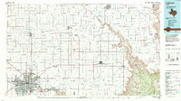
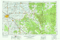
USGS Topo · Published 1986This historical map portrays the area of Lubbock in 1986, primarily covering Lubbock as well as portions of Dickens County, Motley County, Hale County, Floyd County, and Crosby County. Featuring a scale of 1:100000, this map provides a highly detailed snapshot of the terrain, roads, buildings, counties, and historical landmarks in the Lubbock region at the time. Published in 1986, it is one of 2 known editions of this map due to revisions or reprints.
Map Details
Date Portrayed1986
Date Published1986
PublisherU.S. Geological Survey
Map TypeTopographic
Scale1:100000
Physical Dimensions42.5 x 23.8 inches
Editions of this 1986 Lubbock Map
2 editions found
Historical Maps of Wake Through Time
3 maps found

Featured Locations
Source Details
SourceU.S. Geological Survey
CopyrightPublic Domain