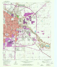
1957 Map of Lubbock East
USGS Topo · Published 1977About this map
Texas Technological University anchors the western edge of this Lubbock landscape, reflecting a period of significant urban growth that expanded toward Yellow House Canyon. The map reveals a dense network of local schools and civic landmarks, from the central Lubbock High Sch to neighborhood anchors like Wheatley Sch and Bozeman Sch. In the north, Mac Kenzie State Park follows the winding path of Blackwater Draw, while the Texas Agricultural Experiment Station highlights the intersection of academic research and the regional economy. To the southeast, the terrain drops into the rugged breaks of the canyon where Gravel Pits and Caliche Pits operated near the Atchison Topeka and Santa Fe rail line. This 1970s revision captures the city as residential footprints pushed toward the City Bdy and the outlying settlement of Burris.
Find a feature on this map
58 named features on this map. Tap any name to fly to it.
Don’t see what you’re looking for? This feature index may not catch every label — zoom into the map to look around manually.
Map Details
Editions of this 1957 Lubbock East Map
4 editions found
Other maps of this area

1954 · Lubbock
USGS Topo · 1:250,000

1956 · Shallowater
USGS Topo · 1:24,000

1956 · New Deal
USGS Topo · 1:24,000

1957 · Lubbock East
USGS Topo · 1:24,000

1957 · New Home
USGS Topo · 1:62,500

1957 · Lubbock West
USGS Topo · 1:24,000

1957 · Lubbock
USGS Topo · 1:62,500

1965 · Slaton
USGS Topo · 1:24,000

1965 · Buffalo Springs Lake
USGS Topo · 1:24,000

1965 · Idalou
USGS Topo · 1:24,000