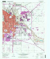
1957 Map of Lubbock East
USGS Topo · Published 1977About this map
Texas Technological University anchors the western edge of this Lubbock survey, providing a clear view of the city’s mid-century academic and urban core. The landscape is defined by the sharp descent of Yellow House Canyon, where the Blackwater Draw and Yellow House Draw converge to form the Double Mountain Fork Brazos River. This natural drainage system cuts through the high plains, offering a stark contrast to the rigid grid of the city streets.
Find a feature on this map
80 named features on this map. Tap any name to fly to it.
Don’t see what you’re looking for? This feature index may not catch every label — zoom into the map to look around manually.
Map Details
Editions of this 1957 Lubbock East Map
4 editions found
Other maps of this area

1954 · Lubbock
USGS Topo · 1:250,000

1956 · Shallowater
USGS Topo · 1:24,000

1956 · New Deal
USGS Topo · 1:24,000

1957 · Lubbock East
USGS Topo · 1:24,000

1957 · New Home
USGS Topo · 1:62,500

1957 · Lubbock West
USGS Topo · 1:24,000

1957 · Lubbock
USGS Topo · 1:62,500

1965 · Slaton
USGS Topo · 1:24,000

1965 · Buffalo Springs Lake
USGS Topo · 1:24,000

1965 · Idalou
USGS Topo · 1:24,000