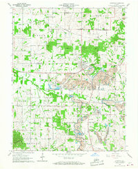
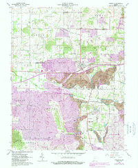
1960 Map of Lynnville
USGS Topo · Published 1968About this map
Large-scale extractive industry dominates the landscape around Lynnville in the early 1960s, where extensive Strip Mines and the Lynnville Mine have reshaped the terrain across Hart and Monroe townships. The New York Central railroad serves these industrial operations, cutting through a countryside otherwise defined by scattered rural settlements like Stanley and Graham Valley. High points such as Ringham Hill and Dyson Knob overlook a network of small family cemeteries and country churches that speak to the area's pioneer roots. Genealogists will find numerous burial grounds preserved amidst the changing land use, including Kilpatrick Cem, Eden Cem, and Massey Cem. The drainage patterns of Little Creek and Fork Smith Fork provide the natural structure for the townships of Barton, Greer, and Campbell, even as industrial pits and spoil banks alter the local topography.
Find a feature on this map
41 named features on this map. Tap any name to fly to it.
Don’t see what you’re looking for? This feature index may not catch every label — zoom into the map to look around manually.
Map Details
Editions of this 1960 Lynnville Map
5 editions found
Other maps of this area

1900 · De Gonia Springs
USGS Topo · 1:62,500

1902 · Ditney
USGS Topo · 1:125,000

1902 · Degonia Springs
USGS Topo · 1:62,500

1902 · Boonville
USGS Topo · 1:62,500

1903 · Velpen
USGS Topo · 1:62,500

1903 · Petersburg
USGS Topo · 1:62,500

1956 · Vincennes
USGS Topo · 1:250,000

1957 · Vincennes
USGS Topo · 1:250,000

1958 · Vincennes
USGS Topo · 1:250,000
1960 · De Gonia Springs
USGS Topo · 1:24,000