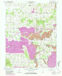
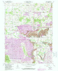
1960 Map of Lynnville
USGS Topo · Published 1981About this map
Industrial coal operations and rural farming communities intersect at Lynnville, where the landscape of southern Indiana underwent significant transformation by the early 1960s. The presence of extensive Strip Mines and the Lynnville Mine dominates the central terrain, cutting across established boundaries between Barton, Hart, and Greer townships. These mining activities are interwoven with a dense network of country roads like N 1000 RD and the tracks of the Conrail railroad, which served the region's extraction economy.
Find a feature on this map
51 named features on this map. Tap any name to fly to it.
Don’t see what you’re looking for? This feature index may not catch every label — zoom into the map to look around manually.
Map Details
Editions of this 1960 Lynnville Map
5 editions found
Other maps of this area

1900 · De Gonia Springs
USGS Topo · 1:62,500

1902 · Ditney
USGS Topo · 1:125,000

1902 · Degonia Springs
USGS Topo · 1:62,500

1902 · Boonville
USGS Topo · 1:62,500

1903 · Velpen
USGS Topo · 1:62,500

1903 · Petersburg
USGS Topo · 1:62,500

1956 · Vincennes
USGS Topo · 1:250,000

1957 · Vincennes
USGS Topo · 1:250,000

1958 · Vincennes
USGS Topo · 1:250,000
1960 · De Gonia Springs
USGS Topo · 1:24,000