
1959 Map of Madison
USGS Topo · Published 1959About this map
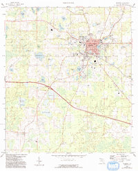
Madison serves as the regional hub in this 1950s survey, showing a concentrated urban core supported by the Seaboard Air Line and Georgia & Florida railroads. The town's institutional landscape is well-documented, featuring the North Florida Junior College, the County Training Sch, and the Madison Country Club. Beyond the city limits, the terrain transition into a mosaic of wetlands and prairies, including Messer Prairie and Hankings Prairie, punctuated by numerous named water bodies such as Mystic Lake and Lake Rachel. Smaller rural communities like Hopewell and outlying landmarks such as Bethlehem Sch and St Lukes Ch illustrate the distributed settlement pattern of the Florida Panhandle during this era. The map also identifies local industry and infrastructure, from the Brickyard Pond to the early Sewage Disposal system, providing a detailed look at the county seat’s mid-century development.
Find a feature on this map
54 named features on this map. Tap any name to fly to it.
Don’t see what you’re looking for? This feature index may not catch every label — zoom into the map to look around manually.
Map Details
Editions of this 1959 Madison Map
2 editions found
Other maps of this area

1954 · Greenville NE
USGS Topo · 1:24,000

1954 · Valdosta
USGS Topo · 1:250,000

1955 · Greenville SE
USGS Topo · 1:24,000

1958 · Valdosta
USGS Topo · 1:250,000

1958 · Madison SW
USGS Topo · 1:24,000

1958 · Madison SE
USGS Topo · 1:24,000

1958 · Lee
USGS Topo · 1:24,000

1959 · Valdosta
USGS Topo · 1:250,000

1960 · Cherry Lake
USGS Topo · 1:24,000

1960 · Pinetta
USGS Topo · 1:24,000