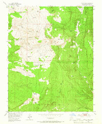
1953 Map of Magote Peak
USGS Topo · Published 1966About this map
Magote Peak and the high Magote Ridge define this mid-century look at the southern reaches of the Carson National Forest. The landscape is a network of deep drainage systems like Montoya Canyon and Oso Canyon, interspersed with localized watering points essential for ranching and forest operations. Settlements and camps such as Magotito, Rancherilla, and Harris Bear Camp suggest a seasonal or specialized use of the high country, likely tied to grazing and timber.
Find a feature on this map
47 named features on this map. Tap any name to fly to it.
Don’t see what you’re looking for? This feature index may not catch every label — zoom into the map to look around manually.
Map Details
Editions of this 1953 Magote Peak Map
5 editions found
Other maps of this area

1918 · Abiquiu
USGS Topo · 1:125,000

1918 · Tusas
USGS Topo · 1:125,000

1953 · Valle Grande Peak
USGS Topo · 1:24,000

1953 · Magote Peak
USGS Topo · 1:24,000

1953 · Canjilon
USGS Topo · 1:24,000

1953 · El Rito
USGS Topo · 1:24,000

1953 · Canjilon SE
USGS Topo · 1:24,000

1953 · Ghost Ranch
USGS Topo · 1:24,000

1954 · Aztec
USGS Topo · 1:250,000

1955 · Cebolla
USGS Topo · 1:62,500