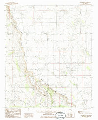
1985 Map of Maljamar NE
USGS Topo · Published 1985About this map
The Mescalero (The Caprock) Ridge dominates this high-plains landscape, carving a sharp escarpment that defines the boundary between the Llano Estacado and the Pecos River Valley. In the mid-1980s, this area of Eddy County served as a significant industrial hub for petroleum extraction, characterized by an extensive Oil Field and supporting infrastructure like the Pumping Station and several Radio Tower sites. The terrain is marked by topographic high points such as Taylor Peak and the drainage of Taylor Draw, which reveal the natural drainage patterns of this semi-arid environment. This 1985 survey captures the intersection of three counties — Chaves, Lea, and Eddy — during a period when the energy sector deeply shaped the New Mexico desert through a network of roads, pipelines, and a local Gravel Pit.
Find a feature on this map
11 named features on this map. Tap any name to fly to it.
Don’t see what you’re looking for? This feature index may not catch every label — zoom into the map to look around manually.
Map Details
Editions of this 1985 Maljamar NE Map
This is the sole edition of this map. No revisions or reprints were ever made.
Other maps of this area

1954 · Hobbs
USGS Topo · 1:250,000

1954 · Brownfield
USGS Topo · 1:250,000

1958 · Brownfield
USGS Topo · 1:250,000

1958 · Hobbs
USGS Topo · 1:250,000

1962 · Brownfield
USGS Topo · 1:250,000

1962 · Buckeye
USGS Topo · 1:62,500

1963 · Maljamar
USGS Topo · 1:62,500
1973 · Cedar Point
USGS Topo · 1:24,000

1973 · Dean Ranch
USGS Topo · 1:24,000
1973 · Cedar Point SE
USGS Topo · 1:24,000