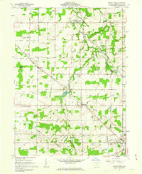
1961 Map of Mallet Creek
USGS Topo · Published 1963About this map
The West Branch Rocky River meanders through this portion of the Connecticut Western Reserve, where rural life in the early 1960s was defined by small farming hamlets and a dual railroad infrastructure. The Baltimore and Ohio Railroad cuts diagonally across the landscape, intersecting with the Akron Canton and Youngstown Railroad near the settlement of Lester. This junction, along with the proximity of Erhart and Mallet Creek, illustrates a period when rail lines still dictated the growth of small Ohio communities before the dominance of interstate travel.
Find a feature on this map
49 named features on this map. Tap any name to fly to it.
Don’t see what you’re looking for? This feature index may not catch every label — zoom into the map to look around manually.
Map Details
Editions of this 1961 Mallet Creek Map
4 editions found
Other maps of this area

1901 · Oberlin
USGS Topo · 1:62,500

1902 · Berea
USGS Topo · 1:62,500

1903 · Oberlin
USGS Topo · 1:62,500

1904 · Berea
USGS Topo · 1:62,500

1904 · Medina
USGS Topo · 1:62,500

1904 · Wellington
USGS Topo · 1:62,500

1906 · Medina
USGS Topo · 1:62,500

1906 · Wellington
USGS Topo · 1:62,500

1950 · Cleveland
USGS Topo · 1:250,000

1953 · West View
USGS Topo · 1:24,000