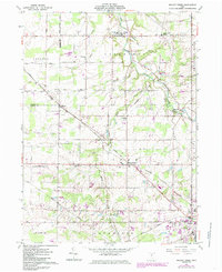
1961 Map of Mallet Creek
USGS Topo · Published 1985About this map
The West Branch Rocky River carves through the northeastern corner of this landscape, flanked by the Brunswick Hills as it flows past the settlement of Abbeyville. This transition from the elevated terrain in the east to the flatter agricultural reaches of Liverpool and York townships is defined by a dense network of early 1960s rural infrastructure. The Baltimore and Ohio railroad corridor serves as a primary axis, connecting small rail-stop communities like Erhart, Lester, and Valley City Station.
Find a feature on this map
46 named features on this map. Tap any name to fly to it.
Don’t see what you’re looking for? This feature index may not catch every label — zoom into the map to look around manually.
Map Details
Editions of this 1961 Mallet Creek Map
4 editions found
Other maps of this area

1901 · Oberlin
USGS Topo · 1:62,500

1902 · Berea
USGS Topo · 1:62,500

1903 · Oberlin
USGS Topo · 1:62,500

1904 · Berea
USGS Topo · 1:62,500

1904 · Medina
USGS Topo · 1:62,500

1904 · Wellington
USGS Topo · 1:62,500

1906 · Medina
USGS Topo · 1:62,500

1906 · Wellington
USGS Topo · 1:62,500

1950 · Cleveland
USGS Topo · 1:250,000

1953 · West View
USGS Topo · 1:24,000