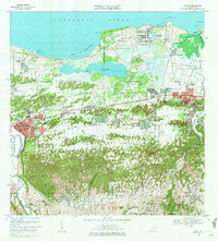
1969 Map of Manati
USGS Topo · Published 1972About this map
The coastal wetlands and limestone hills of northern Puerto Rico define this landscape, dominated by the expansive Laguna Tortuguero and the surrounding National Guard Reservation. This survey documents the transition from the marine environments of Puerto del Tortuguero to the dense network of rural barrios and developing urban centers. To the east, Vega Baja is shown with its Tribunal de Distrito and Colegio Nuestra Señora del Rosario, while the western edge captures the growth of Pueblo Saliente and Pueblo Poniente.
Find a feature on this map
96 named features on this map. Tap any name to fly to it.
Don’t see what you’re looking for? This feature index may not catch every label — zoom into the map to look around manually.
Map Details
Editions of this 1969 Manati Map
4 editions found
Other maps of this area

1940 · Vega Alta
USGS Topo · 1:30,000

1942 · Manati
USGS Topo · 1:30,000

1942 · Barceloneta
USGS Topo · 1:30,000

1946 · Corozal
USGS Topo · 1:30,000

1946 · Barceloneta
USGS Topo · 1:30,000

1946 · Ciales
USGS Topo · 1:30,000

1946 · Florida
USGS Topo · 1:30,000

1946 · Vega Alta
USGS Topo · 1:30,000

1946 · Manati
USGS Topo · 1:30,000

1947 · Corozal NO
USGS Topo · 1:10,000