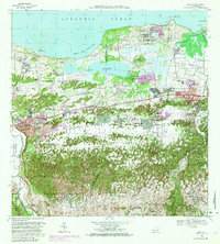
1969 Map of Manati
USGS Topo · Published 1983About this map
Laguna Tortuguero dominates the northern coastal landscape between the Municipio de Manatí and Municipio de Vega Baja, serving as a central geographical landmark before the terrain rises into the mogotes of the south. This 1969 survey, photorevised in the early 1980s, captures a transition from the industrial and residential centers of Pueblo Saliente and Vega Baja to the specialized military and aviation footprints of the U.S. Army Military Reservation and the nearby Pista de Aterrizaje.
Find a feature on this map
73 named features on this map. Tap any name to fly to it.
Don’t see what you’re looking for? This feature index may not catch every label — zoom into the map to look around manually.
Map Details
Editions of this 1969 Manati Map
4 editions found
Other maps of this area

1940 · Vega Alta
USGS Topo · 1:30,000

1942 · Manati
USGS Topo · 1:30,000

1942 · Barceloneta
USGS Topo · 1:30,000

1946 · Corozal
USGS Topo · 1:30,000

1946 · Barceloneta
USGS Topo · 1:30,000

1946 · Ciales
USGS Topo · 1:30,000

1946 · Florida
USGS Topo · 1:30,000

1946 · Vega Alta
USGS Topo · 1:30,000

1946 · Manati
USGS Topo · 1:30,000

1947 · Corozal NO
USGS Topo · 1:10,000