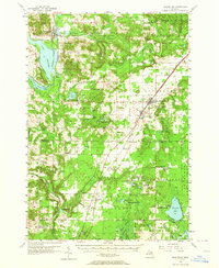
1956 Map of Mancelona
USGS Topo · Published 1964About this map
Mancelona serves as a central hub on this mid-century survey, situated at the junction of the Pennsylvania railroad and the Chesapeake and Ohio line. The landscape is characterized by a high density of small lakes and extensive timberlands within the Pigeon River State Forest and Au Sable State Forest. Evidence of a changing rural infrastructure is visible in the numerous decommissioned local schoolhouses, such as the Day Sch, Miller Sch, and Lamin Sch. These sites, along with several family and community burial grounds like Fairview Cem and Chapman Cem, provide essential anchor points for genealogists tracing the early residents of Antrim and Leetsville. To the northwest, the prominent Bellaire Lake and Clam Lake define the western boundary, while the Jordan River flows through the northern reaches of the quadrangle.
Find a feature on this map
90 named features on this map. Tap any name to fly to it.
Don’t see what you’re looking for? This feature index may not catch every label — zoom into the map to look around manually.
Map Details
Editions of this 1956 Mancelona Map
4 editions found
Other maps of this area

1949 · Black Creek
USGS Topo · 1:24,000

1949 · Fletcher
USGS Topo · 1:62,500

1954 · Central Lake
USGS Topo · 1:62,500

1954 · Traverse City
USGS Topo · 1:250,000

1955 · Cheboygan
USGS Topo · 1:250,000

1956 · Alba
USGS Topo · 1:62,500

1956 · Mancelona
USGS Topo · 1:62,500

1956 · Kalkaska
USGS Topo · 1:62,500

1956 · Fife Lake
USGS Topo · 1:62,500

1957 · Elk Rapids
USGS Topo · 1:62,500