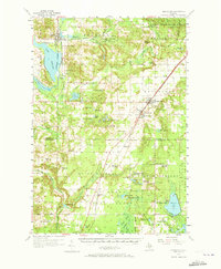
1956 Map of Mancelona
USGS Topo · Published 1973About this map
The village of Mancelona stands as a focal point in the 1950s, where the Pennsylvania RR intersects with the local road network. This landscape reveals a period of transition, noted by the high concentration of inactive rural infrastructure. No fewer than six educational sites, including the Day Sch and Miller Sch, are marked as abandoned, suggesting a shift in population or the consolidation of rural school districts into town centers.
Find a feature on this map
89 named features on this map. Tap any name to fly to it.
Don’t see what you’re looking for? This feature index may not catch every label — zoom into the map to look around manually.
Map Details
Editions of this 1956 Mancelona Map
4 editions found
Other maps of this area

1949 · Black Creek
USGS Topo · 1:24,000

1949 · Fletcher
USGS Topo · 1:62,500

1954 · Central Lake
USGS Topo · 1:62,500

1954 · Traverse City
USGS Topo · 1:250,000

1955 · Cheboygan
USGS Topo · 1:250,000

1956 · Alba
USGS Topo · 1:62,500

1956 · Mancelona
USGS Topo · 1:62,500

1956 · Kalkaska
USGS Topo · 1:62,500

1956 · Fife Lake
USGS Topo · 1:62,500

1957 · Elk Rapids
USGS Topo · 1:62,500