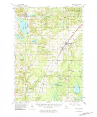
1956 Map of Mancelona
USGS Topo · Published 1984About this map
Mancelona stands as a primary crossroads for the Pennsylvania Railroad and regional thoroughfares during the mid-1950s, serving as a gateway between the forests and lakes of Northern Michigan. The landscape reflects a transition in rural education and social infrastructure, evidenced by numerous facilities marked as defunct, such as Day Sch, Barber Sch, and Lamin Sch. This era captures the region's character as a timber and recreation hub, with large swaths of the Mackinaw State Forest and Kalkaska State Forest bordering established settlements. To the west, Bellaire is positioned along the waters of Intermediate Lake and the Intermediate River, while the Meadow Brook Hospital and Bellaire Country Club indicate the town's role as a local service and leisure center. The mapping of cemeteries like Morey Cem and Maple Grove Cem provides essential spatial data for local genealogy.
Find a feature on this map
89 named features on this map. Tap any name to fly to it.
Don’t see what you’re looking for? This feature index may not catch every label — zoom into the map to look around manually.
Map Details
Editions of this 1956 Mancelona Map
4 editions found
Other maps of this area

1949 · Black Creek
USGS Topo · 1:24,000

1949 · Fletcher
USGS Topo · 1:62,500

1954 · Central Lake
USGS Topo · 1:62,500

1954 · Traverse City
USGS Topo · 1:250,000

1955 · Cheboygan
USGS Topo · 1:250,000

1956 · Alba
USGS Topo · 1:62,500

1956 · Mancelona
USGS Topo · 1:62,500

1956 · Kalkaska
USGS Topo · 1:62,500

1956 · Fife Lake
USGS Topo · 1:62,500

1957 · Elk Rapids
USGS Topo · 1:62,500