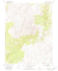
1969 Map of Manhattan Mtn
USGS Topo · Published 1984About this map
Manhattan Mountain and Ravenswood Peak dominate this high-altitude landscape in Lander County, where the terrain drops sharply toward the valley floor. The eastern edge of the quadrangle follows the course of the Reese River, a vital water source for the region's ranching and transit history. Evidence of early infrastructure is visible along the river's path, most notably the Old Railroad Grade that winds through the lowlands alongside a Jeep Trail.
Find a feature on this map
18 named features on this map. Tap any name to fly to it.
Don’t see what you’re looking for? This feature index may not catch every label — zoom into the map to look around manually.
Map Details
Editions of this 1969 Manhattan Mtn Map
2 editions found
Other maps of this area

1955 · Millett
USGS Topo · 1:250,000

1959 · Millett
USGS Topo · 1:250,000

1969 · Manhattan Mtn
USGS Topo · 1:24,000

1969 · Gilbert Creek SE
USGS Topo · 1:24,000

1969 · Joe Eason Mtn
USGS Topo · 1:24,000
1969 · Manhattan Mtn NW
USGS Topo · 1:24,000

1969 · Vigus Butte NE
USGS Topo · 1:24,000
1969 · Gilbert Creek NE
USGS Topo · 1:24,000

1969 · Vigus Butte NW
USGS Topo · 1:24,000

1969 · Mount Airy NE
USGS Topo · 1:24,000