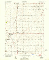
1953 Map of Manhattan
USGS Topo · Published 1955About this map
The village of Manhattan serves as a central junction for three major rail lines in the early 1950s, where the Wabash and Chicago Milwaukee St Paul and Pacific tracks intersect south of the Elgin Joliet and Eastern line. This survey captures a rural Illinois landscape transitioning into a more industrial era, evidenced by the Tank Farm positioned along the western rail corridor. Despite these developments, the area maintains its agricultural roots, organized around landmarks like the Green Garden Ch and rural education centers such as Reiter Sch.
Find a feature on this map
25 named features on this map. Tap any name to fly to it.
Don’t see what you’re looking for? This feature index may not catch every label — zoom into the map to look around manually.
Map Details
Editions of this 1953 Manhattan Map
3 editions found
Other maps of this area

1890 · Des Plaines
USGS Topo · 1:62,500

1892 · Joliet
USGS Topo · 1:62,500

1892 · Wilmington
USGS Topo · 1:62,500

1894 · Des Plaines
USGS Topo · 1:62,500

1900 · Des Plaines
USGS Topo · 1:62,500

1901 · Des Plaines
USGS Topo · 1:62,500

1918 · Wilmington
USGS Topo · 1:62,500

1923 · Joliet
USGS Topo · 1:62,500

1929 · Tinley Park
USGS Topo · 1:24,000

1929 · Brisbane
USGS Topo · 1:24,000