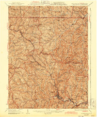
1926 Map of Mannington
USGS Topo · Published 1943About this map
Mannington serves as the industrial and social anchor of this 1920s landscape, situated at the junction of Buffalo Creek and the B. & O. R. R.. The map illustrates a dense network of early 20th-century life in Marion and Monongalia Counties, where small hollows are populated by dozens of country schools and family-named landmarks. Notable rural centers include Hundred, Glover Gap, and Saint Cloud. The topography is defined by narrow ridges and winding runs, such as Warrior Fork and Davy Run, which dictated the placement of early settlements and roads. Genealogists may find interest in the numerous specific educational and religious sites, ranging from The Little Red Church to the Flaggy Meadow School and Valley Chapel. The crossing of the West Virginia and Pennsylvania state line is clearly marked, showing the proximity of border communities like Jollytown and Brave P.O..
Find a feature on this map
171 named features on this map. Tap any name to fly to it.
Don’t see what you’re looking for? This feature index may not catch every label — zoom into the map to look around manually.
Map Details
Editions of this 1926 Mannington Map
2 editions found

Other maps of this area

1901 · Waynesburg
USGS Topo · 1:62,500

1902 · Clarksburg
USGS Topo · 1:62,500

1902 · Fairmont
USGS Topo · 1:62,500

1903 · Littleton
USGS Topo · 1:62,500

1904 · Blacksville
USGS Topo · 1:62,500

1904 · Waynesburg
USGS Topo · 1:62,500

1904 · Cameron
USGS Topo · 1:62,500

1905 · Mannington
USGS Topo · 1:62,500

1905 · Rogersville
USGS Topo · 1:62,500

1905 · Centerpoint
USGS Topo · 1:62,500