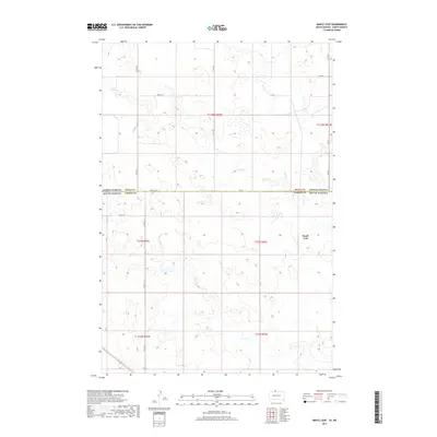
2017 Map of Maple Leaf
USGS Topo · Published 2017About this map
Maple Leaf sits in the southeastern quadrant of this prairie landscape, marking a specific point of settlement within the Corson Co portion of the Standing Rock Reservation. The geography is defined by the winding course of Oak Cr, which meanders across the northern half of the sheet, carving subtle drainage patterns through the high plains. This 2017 survey reveals the intersection of South Dakota and North Dakota, where State Line St and Cr 165 trace the political boundary between the two states. The rural infrastructure is largely composed of a geometric grid of section lines and local routes such as Co Rd 13-2, connecting isolated farmsteads and agricultural plots. The map provides a contemporary view of this borderland region, documenting the persistent ranching and farming layouts that have shaped the territory since the late nineteenth century.
Find a feature on this map
19 named features on this map. Tap any name to fly to it.
Don’t see what you’re looking for? This feature index may not catch every label — zoom into the map to look around manually.
Map Details
Editions of this 2017 Maple Leaf Map
This is the sole edition of this map. No revisions or reprints were ever made.
Other maps of this area

1953 · McIntosh
USGS Topo · 1:250,000

1954 · Bismarck
USGS Topo · 1:250,000

1956 · Bullhead
USGS Topo · 1:24,000

1958 · Bismarck
USGS Topo · 1:250,000

1958 · McIntosh
USGS Topo · 1:250,000

1966 · McLaughlin
USGS Topo · 1:24,000

1966 · McLaughlin NE
USGS Topo · 1:24,000
1971 · Selfridge SE
USGS Topo · 1:24,000

1971 · Selfridge
USGS Topo · 1:24,000

1971 · Pamplin Hills
USGS Topo · 1:24,000
Featured Places
- McLaughlin, SD
- Fort Yates District, ND
- Porcupine District, ND
- Rock Creek District, SD
- Maple Leaf, McLaughlin