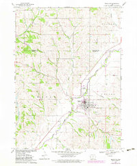
1969 Map of Mapleton
USGS Topo · Published 1983About this map
Maple River floodplains and the surrounding Loess Hills topography define this landscape in western Iowa. The town of Mapleton sits at a low-lying junction where several drainages, including Simmons Creek and Heisler Creek, converge toward the river valley. The map documents the community's mid-century infrastructure, featuring the Mapleton Municipal Airport and a river Gaging Station.
Find a feature on this map
21 named features on this map. Tap any name to fly to it.
Don’t see what you’re looking for? This feature index may not catch every label — zoom into the map to look around manually.
Map Details
Editions of this 1969 Mapleton Map
2 editions found
Other maps of this area

1954 · Fort Dodge
USGS Topo · 1:250,000

1957 · Fort Dodge
USGS Topo · 1:250,000

1958 · Fort Dodge
USGS Topo · 1:250,000

1969 · Danbury
USGS Topo · 1:24,000

1969 · Holstein SW
USGS Topo · 1:24,000

1969 · Mapleton
USGS Topo · 1:24,000

1969 · Castana
USGS Topo · 1:24,000
1969 · Smithland
USGS Topo · 1:24,000
1969 · Oto
USGS Topo · 1:24,000
1969 · Correctionville SE
USGS Topo · 1:24,000