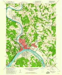
1957 Map of Marietta
USGS Topo · Published 1960About this map
The confluence of the Muskingum River and the Ohio River serves as the focal point for this late 1950s survey of Marietta and Williamstown. The map captures the dense urban core of Marietta, highlighting prominent civic landmarks such as the Campus Martius Museum and the Ft Harmar Monument, which mark the area's deep frontier roots. Residential expansion is visible across established neighborhoods like Harmar, Norwood, and Putnam Place, while the surrounding hills remain dotted with numerous oil wells, represented by small brown dots. Transport networks of the Baltimore and Ohio and Pennsylvania railroads follow the riverbanks, supporting local industry and the transit of goods through the valley. Along Duck Creek and the river bends, smaller settlements such as DeVola and Stanleyville maintain their distinct identities amidst the winding waterway topography.
Find a feature on this map
96 named features on this map. Tap any name to fly to it.
Don’t see what you’re looking for? This feature index may not catch every label — zoom into the map to look around manually.
Map Details
Editions of this 1957 Marietta Map
2 editions found
Other maps of this area

1902 · Parkersburg
USGS Topo · 1:62,500

1903 · Macksburg
USGS Topo · 1:62,500

1904 · Parkersburg
USGS Topo · 1:62,500

1904 · Marietta
USGS Topo · 1:62,500

1905 · Macksburg
USGS Topo · 1:62,500

1909 · Caldwell
USGS Topo · 1:62,500

1912 · Caldwell
USGS Topo · 1:62,500

1924 · Marietta
USGS Topo · 1:62,500

1927 · Marietta
USGS Topo · 1:62,500

1949 · Clarksburg
USGS Topo · 1:250,000