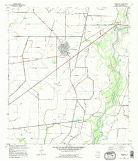
1995 Map of Markham
USGS Topo · Published 1995About this map
The Colorado River corridor defines this coastal prairie landscape in the 1990s, where extensive systems of Levees manage the waterway's influence on the surrounding oil and agricultural lands. Near the grid of Markham, the North Markham Oil Field and numerous scattered Oil Wells and Gas Wells indicate a persistent petroleum economy. An Old Railroad Grade cuts across the terrain, reflecting the evolution of transportation in Matagorda County as rail gave way to the network of roads and pipelines shown here.
Find a feature on this map
20 named features on this map. Tap any name to fly to it.
Don’t see what you’re looking for? This feature index may not catch every label — zoom into the map to look around manually.
Map Details
Editions of this 1995 Markham Map
This is the sole edition of this map. No revisions or reprints were ever made.
Other maps of this area

1950 · Houston
USGS Topo · 1:250,000

1951 · Bay City
USGS Topo · 1:250,000

1951 · Danevang
USGS Topo · 1:24,000

1952 · Lane City SE
USGS Topo · 1:24,000

1952 · Blessing SE
USGS Topo · 1:24,000

1952 · Blessing
USGS Topo · 1:24,000

1952 · Bay City
USGS Topo · 1:24,000

1952 · Markham
USGS Topo · 1:24,000

1952 · Van Vleck
USGS Topo · 1:24,000

1952 · Midfield
USGS Topo · 1:24,000