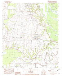
1982 Map of Marksville South
USGS Topo · Published 1982About this map
Central Avoyelles Parish is defined by its intricate drainage patterns and the historic settlements of Marksville, Mansura, and Hessmer. This 1982 provisional survey documents a landscape of numerous small lakes and coulees, notably the extensive Spring Bayou State Wildlife Management Area and the winding course of Bayou des Glaises. The industrial and transportation backbone of the area is represented by the Kansas City Southern railroad, which cuts through the heart of Mansura, and the Marksville Municipal Airport. Local genealogy is well-supported by detailed locations for community landmarks like the Jerusalem Cem and St Pauls Ch, alongside smaller settlements like Cocoville, Moreauville, and Long Bridge. The map captures the parish's unique alluvial geography, where complex water bodies like Lac aux Perles and Coulee des Grues dictate the placement of roads and farms.
Find a feature on this map
41 named features on this map. Tap any name to fly to it.
Don’t see what you’re looking for? This feature index may not catch every label — zoom into the map to look around manually.
Map Details
Editions of this 1982 Marksville South Map
2 editions found
Other maps of this area

1940 · Marksville
USGS Topo · 1:62,500

1941 · Voorhies
USGS Topo · 1:62,500

1948 · Bunkie
USGS Topo · 1:62,500

1952 · Lake Charles
USGS Topo · 1:250,000

1953 · Alexandria
USGS Topo · 1:250,000

1953 · Natchez
USGS Topo · 1:250,000

1954 · Lake Charles
USGS Topo · 1:250,000

1954 · Baton Rouge
USGS Topo · 1:250,000

1955 · Odenburg
USGS Topo · 1:62,500

1955 · Alexandria
USGS Topo · 1:250,000