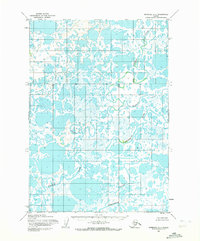
1954 Map of Marshall A-1
USGS Topo · Published 1972About this map
The Johnson River snakes across a low-lying alluvial landscape in this mid-century survey, showcasing the complex hydrologic patterns of the Yukon-Kuskokwim Delta region. This environment is characterized by an intricate network of wandering channels and countless water bodies, including the prominent Kalasik Lake. The intricate path of the Pikmiktalik River and the Kvichavak River illustrate a terrain defined by seasonal flux and shifting currents. With no roads or trails recorded, the reliance on watercourses for travel and subsistence is evident. The mapping, based on 1951 and 1952 aerial photography, preserves the exact positioning of features like Puk Palik Cr before subsequent decades of permafrost change and silt migration altered these waterways.
Find a feature on this map
5 named features on this map. Tap any name to fly to it.
Don’t see what you’re looking for? This feature index may not catch every label — zoom into the map to look around manually.
Map Details
Editions of this 1954 Marshall A-1 Map
2 editions found
Other maps of this area

1947 · Russian Mission
USGS Topo · 1:250,000

1950 · Russian Mission
USGS Topo · 1:250,000

1950 · Bethel
USGS Topo · 1:250,000

1951 · Marshall
USGS Topo · 1:250,000

1951 · Baird Inlet
USGS Topo · 1:250,000

1952 · Russian Mission B-8
USGS Topo · 1:63,360

1954 · Russian Mission A-8
USGS Topo · 1:63,360

1954 · Marshall A-2
USGS Topo · 1:63,360

1954 · Marshall A-1
USGS Topo · 1:63,360
1954 · Marshall B-2
USGS Topo · 1:63,360