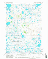
1953 Map of Marshall B-6
USGS Topo · Published 1968About this map
Ingakslugwat Hills rise as a series of distinctive landforms above a complex network of unnamed lakes and wetlands in this remote coastal Alaska landscape. The terrain is defined by a dense concentration of water bodies and marshland, much of which is encompassed by the Clarence Rhode National Wildlife Range Area No 1. The 1953 mapping by the Army Map Service and Geological Survey reveals a territory largely devoid of permanent human settlements or infrastructure at the time, instead prioritizing the documentation of geographic boundaries and topographical elevations. An Indefinite Boundary transects the sheet, highlighting the challenges of surveying this watery environment, while the unmarked land lines were predetermined by the Bureau of Land Management rather than field-checked on the ground.
Find a feature on this map
3 named features on this map. Tap any name to fly to it.
Don’t see what you’re looking for? This feature index may not catch every label — zoom into the map to look around manually.
Map Details
Editions of this 1953 Marshall B-6 Map
2 editions found
Other maps of this area

1951 · Marshall
USGS Topo · 1:250,000

1952 · Marshall C-7
USGS Topo · 1:63,360

1952 · Marshall C-6
USGS Topo · 1:63,360

1952 · Marshall C-5
USGS Topo · 1:63,360
1953 · Marshall A-5
USGS Topo · 1:63,360

1953 · Marshall B-6
USGS Topo · 1:63,360

1953 · Marshall B-7
USGS Topo · 1:63,360

1953 · Marshall B-5
USGS Topo · 1:63,360

1954 · Marshall A-6
USGS Topo · 1:63,360
1954 · Marshall A-7
USGS Topo · 1:63,360