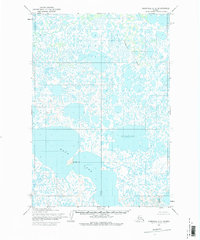
1952 Map of Marshall C-5
USGS Topo · Published 1983About this map
Taktusak Hill rises above a sprawling wetland complex in this 1952 topographic record of the Yukon-Kuskokwim Delta region. The landscape is defined by an intricate network of unnamed ponds and marshes, typical of the Alaskan tundra, where large bodies of water like Kingaglia Lake and Kgun Lake serve as the primary geographical anchors. Mapping by the Army Map Service reveals a territory devoid of permanent roads or established settlements at the time, dominated instead by natural drainage patterns such as Chakaktolik Creek. This survey provides a critical baseline for understanding the hydrologic character of the Kusilvak area before modern environmental shifts, capturing the predetermined township and range lines established by the Bureau of Land Management for a wilderness that remained largely unsurveyed on the ground.
Find a feature on this map
10 named features on this map. Tap any name to fly to it.
Don’t see what you’re looking for? This feature index may not catch every label — zoom into the map to look around manually.
Map Details
Editions of this 1952 Marshall C-5 Map
3 editions found
Other maps of this area

1951 · Marshall
USGS Topo · 1:250,000

1952 · Marshall D-5
USGS Topo · 1:63,360

1952 · Marshall D-4
USGS Topo · 1:63,360

1952 · Marshall C-6
USGS Topo · 1:63,360

1952 · Marshall C-5
USGS Topo · 1:63,360

1952 · Marshall D-6
USGS Topo · 1:63,360

1953 · Marshall B-6
USGS Topo · 1:63,360

1953 · Marshall B-5
USGS Topo · 1:63,360

1954 · Marshall B-4
USGS Topo · 1:63,360

1954 · Marshall C-4
USGS Topo · 1:63,360