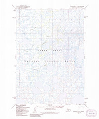
1952 Map of Marshall C-6
USGS Topo · Published 1991About this map
Yukon Delta National Wildlife Refuge dominates this subarctic landscape, where a dense network of sloughs and unnamed ponds defines the terrain. The hydrological complexity is characterized by the winding courses of the Nungatak River and the Manokinak River, which meander through the marshy lowlands typical of this deltaic environment. Based on 1950s aerial photography, the map reveals a wilderness largely devoid of permanent human infrastructure or roads, prioritizing the natural drainage patterns and topographical contours of the region. Kgun Lake sits as a prominent landmark in the southeast, surrounded by the intricate water-and-land interface that makes this portion of Alaska so distinctive for wildlife and water resource study.
Find a feature on this map
4 named features on this map. Tap any name to fly to it.
Don’t see what you’re looking for? This feature index may not catch every label — zoom into the map to look around manually.
Map Details
Editions of this 1952 Marshall C-6 Map
3 editions found
Other maps of this area

1951 · Marshall
USGS Topo · 1:250,000

1952 · Marshall D-5
USGS Topo · 1:63,360

1952 · Marshall C-7
USGS Topo · 1:63,360

1952 · Marshall C-6
USGS Topo · 1:63,360

1952 · Marshall C-5
USGS Topo · 1:63,360
1952 · Marshall D-7
USGS Topo · 1:63,360

1952 · Marshall D-6
USGS Topo · 1:63,360

1953 · Marshall B-6
USGS Topo · 1:63,360

1953 · Marshall B-7
USGS Topo · 1:63,360

1953 · Marshall B-5
USGS Topo · 1:63,360