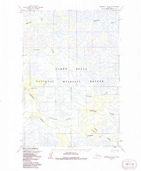
1952 Map of Marshall D-5
USGS Topo · Published 1991About this map
Yukon Delta National Wildlife Refuge dominates this subarctic landscape, characterized by an intricate network of waterways weaving through low-lying marshlands. The drainage pattern is defined by the heavy presence of the Nantok River and the Kashunuk River, which meander across the delta alongside the Maninglik River and Pitmik River. This 1952 field-annotated map reveals the isolation of early Alaska Territory settlements, notably Chakaktolik, which is situated along the banks of Chakaktolik Creek. The geography here reflects a vast, water-bound environment where rivers serve as the primary conduits for travel and subsistence, long before any formal road infrastructure reached this portion of the Kusilvak region. The topography was captured via photogrammetric methods from aerial photographs, illustrating the complex hydrology of the Kipungolak River system in the north.
Find a feature on this map
8 named features on this map. Tap any name to fly to it.
Don’t see what you’re looking for? This feature index may not catch every label — zoom into the map to look around manually.
Map Details
Editions of this 1952 Marshall D-5 Map
3 editions found
Other maps of this area

1951 · Marshall
USGS Topo · 1:250,000

1952 · Kwiguk
USGS Topo · 1:250,000

1952 · Kwiguk A-4
USGS Topo · 1:63,360

1952 · Kwiguk A-3
USGS Topo · 1:63,360

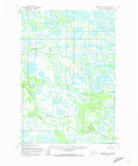
1952 · Marshall D-5
USGS Topo · 1:63,360

1952 · Marshall D-4
USGS Topo · 1:63,360

1952 · Marshall C-6
USGS Topo · 1:63,360

1952 · Marshall C-5
USGS Topo · 1:63,360

1952 · Marshall D-6
USGS Topo · 1:63,360

1954 · Marshall C-4
USGS Topo · 1:63,360