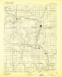
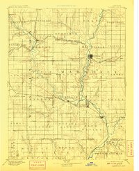
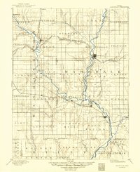
1894 Map of Marysville
USGS Topo · Published 1921About this map
Marysville serves as the central hub of this late-nineteenth-century landscape, positioned at a critical convergence of the Union Pacific Railroad and the Big Blue River. The terrain is deeply carved by the river systems, notably where the Little Blue River joins the main branch near Blue Rapids. This era captures the height of the railroad expansion across northern Kansas, with the Missouri Pacific Railroad and the St Joseph and Grand Island Railroad lacing together small agricultural outposts such as Hollenberg, Bremen, and Irving. The map details a network of townships including Waterville and Blue Rapids City, illustrating a period of established settlement along the fertile creek valleys of Cottonwood Creek and Mill Creek. Minor landmarks like Ballard Falls and Reedsville highlight the localized rural centers that supported the region's early farming economy.
Find a feature on this map
86 named features on this map. Tap any name to fly to it.
Don’t see what you’re looking for? This feature index may not catch every label — zoom into the map to look around manually.
Map Details
Editions of this 1894 Marysville Map
4 editions found
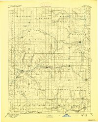
Other maps of this area

1886 · Junction City
USGS Topo · 1:125,000

1889 · Seneca
USGS Topo · 1:125,000

1889 · Wamego
USGS Topo · 1:125,000

1889 · Marysville
USGS Topo · 1:125,000

1889 · Junction City
USGS Topo · 1:125,000

1891 · Clay Center
USGS Topo · 1:125,000

1893 · Washington
USGS Topo · 1:125,000

1894 · Junction City
USGS Topo · 1:125,000
1894 · Seneca
USGS Topo · 1:125,000

1894 · Marysville
USGS Topo · 1:125,000