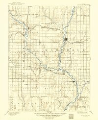
1894 Map of Marysville
USGS Topo · Published 1949About this map
Marysville serves as the central hub of this late 19th-century survey, situated at a critical junction of river valleys and multiple competing rail lines. The landscape is defined by the Little Blue River, which winds south toward Blue Rapids and Waterville, carving through the rolling hills of Marshall and Washington counties. The rail infrastructure of the 1880s is extensively documented, showing the routes of the St Joseph and Grand Island Railroad and the Missouri Pacific Railroad as they facilitated the transport of grain and livestock from regional outposts like Hollenberg and Hanover. Smaller settlements such as Irving and Bigelow follow the Black Vermillion River in the southeast, illustrating how early Kansas pioneers utilized the fertile drainage basins of Horseshoe Creek and Walnut Creek for initial settlement and agriculture before the expansion of the western frontier.
Find a feature on this map
80 named features on this map. Tap any name to fly to it.
Don’t see what you’re looking for? This feature index may not catch every label — zoom into the map to look around manually.
Map Details
Editions of this 1894 Marysville Map
4 editions found
Other maps of this area

1886 · Junction City
USGS Topo · 1:125,000

1889 · Seneca
USGS Topo · 1:125,000

1889 · Wamego
USGS Topo · 1:125,000

1889 · Marysville
USGS Topo · 1:125,000

1889 · Junction City
USGS Topo · 1:125,000

1891 · Clay Center
USGS Topo · 1:125,000

1893 · Washington
USGS Topo · 1:125,000

1894 · Junction City
USGS Topo · 1:125,000

1894 · Seneca
USGS Topo · 1:125,000

1894 · Marysville
USGS Topo · 1:125,000