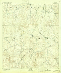
1894 Map of Mason
USGS Topo · Published 1932About this map
Mason serves as the central hub of this Texas Hill Country landscape, captured during an 1885 survey by topographer C. H. Fitch. The map reveals a network of small settlements and post offices connected by primitive roads, including Loyal Valley, Katemcy, and the now-obscure Koockville. The terrain is defined by the significant convergence of the Llano River and the James River, where drainage systems like Honey Creek and Comanche Creek carve through the limestone plateau.
Find a feature on this map
47 named features on this map. Tap any name to fly to it.
Don’t see what you’re looking for? This feature index may not catch every label — zoom into the map to look around manually.
Map Details
Editions of this 1894 Mason Map
4 editions found
Other maps of this area

1885 · San Saba
USGS Topo · 1:125,000

1887 · Llano
USGS Topo · 1:125,000

1887 · Mason
USGS Topo · 1:125,000

1892 · Eden
USGS Topo · 1:125,000

1894 · Brady
USGS Topo · 1:125,000

1894 · Mason
USGS Topo · 1:125,000

1894 · Fredericksburg
USGS Topo · 1:125,000

1894 · Kerrville
USGS Topo · 1:125,000

1894 · San Saba
USGS Topo · 1:125,000

1894 · Llano
USGS Topo · 1:125,000