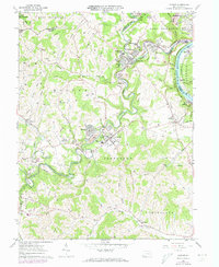
1961 Map of Mather
USGS Topo · Published 1973About this map
The Monongahela River carves the eastern boundary of this Greene County landscape, serving as a vital industrial artery for the surrounding coal country during the mid-20th century. The influence of the mining industry is evident in the specialized housing developments and portals scattered across the terrain, including Teagarden Homes, the Braden Plan, and the Burson Plan near Clarksville. These planned communities, alongside mining operations like the Emerald Mine and Clyde 3 Portal, illustrate the era's reliance on the local coal seams and the Monongahela Railway for transport.
Find a feature on this map
61 named features on this map. Tap any name to fly to it.
Don’t see what you’re looking for? This feature index may not catch every label — zoom into the map to look around manually.
Map Details
Editions of this 1961 Mather Map
3 editions found
Other maps of this area

1900 · Masontown
USGS Topo · 1:62,500

1901 · Amity
USGS Topo · 1:62,500

1901 · Waynesburg
USGS Topo · 1:62,500

1902 · Brownsville
USGS Topo · 1:62,500

1903 · Masontown
USGS Topo · 1:62,500

1904 · Amity
USGS Topo · 1:62,500

1904 · Waynesburg
USGS Topo · 1:62,500

1906 · Brownsville
USGS Topo · 1:62,500

1931 · Brownsville
USGS Topo · 1:62,500

1931 · Masontown
USGS Topo · 1:62,500