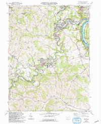
1961 Map of Mather
USGS Topo · Published 1994About this map
Mather and the surrounding coal-country townships of Morgan and Jefferson reveal an industrial landscape shaped by extraction and the winding course of Tenmile Creek. This survey captures the region as it transitioned in the mid-20th century, highlighting the extensive mining infrastructure including the Emerald Mine and the Edwards Shaft Portal Mine. The Monongahela Railway and a complex network of pipelines facilitate the transport of resources across the hilly terrain of West Bethlehem and East Bethlehem.
Find a feature on this map
77 named features on this map. Tap any name to fly to it.
Don’t see what you’re looking for? This feature index may not catch every label — zoom into the map to look around manually.
Map Details
Editions of this 1961 Mather Map
3 editions found
Other maps of this area

1900 · Masontown
USGS Topo · 1:62,500

1901 · Amity
USGS Topo · 1:62,500

1901 · Waynesburg
USGS Topo · 1:62,500

1902 · Brownsville
USGS Topo · 1:62,500

1903 · Masontown
USGS Topo · 1:62,500

1904 · Amity
USGS Topo · 1:62,500

1904 · Waynesburg
USGS Topo · 1:62,500

1906 · Brownsville
USGS Topo · 1:62,500

1931 · Brownsville
USGS Topo · 1:62,500

1931 · Masontown
USGS Topo · 1:62,500