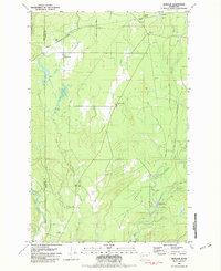
1981 Map of Matlock
USGS Topo · Published 1982About this map
The timber and waterway network of Mason County is clearly visible on this 1981 survey, where logging infrastructure meets the natural flow of the Middle Fork Satsop River. The small settlement of Matlock serves as a focal point, connected to the surrounding woods by a railroad that includes features such as the Frisken Wye and Matlock (Siding). This rail system underscores the era's reliance on fixed transport for the local logging industry.
Find a feature on this map
23 named features on this map. Tap any name to fly to it.
Don’t see what you’re looking for? This feature index may not catch every label — zoom into the map to look around manually.
Map Details
Editions of this 1981 Matlock Map
This is the sole edition of this map. No revisions or reprints were ever made.
Other maps of this area

1921 · Satsop
USGS Topo · 1:62,500

1941 · Mobray
USGS Topo · 1:62,500

1943 · Nahwatzel Lake
USGS Topo · 1:62,500

1943 · Mobray
USGS Topo · 1:62,500

1953 · Mt Tebo
USGS Topo · 1:62,500

1953 · Elma
USGS Topo · 1:62,500

1955 · Wynoochee Valley
USGS Topo · 1:62,500

1955 · Grisdale
USGS Topo · 1:62,500

1958 · Seattle
USGS Topo · 1:250,000

1962 · Seattle
USGS Topo · 1:250,000