
1985 Map of Mt Washington
USGS Topo · Published 1985About this map
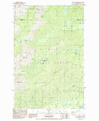
Mt Washington and Jefferson Peak anchor this mid-1980s look at the high wilderness where Jefferson and Mason counties meet. This survey shows the boundary between the Olympic National Park and Olympic National Forest, illustrating the protected watershed of the Hamma Hamma River and its numerous tributaries like Lilliwaup Creek and Jefferson Creek.
Find a feature on this map
36 named features on this map. Tap any name to fly to it.
Don’t see what you’re looking for? This feature index may not catch every label — zoom into the map to look around manually.
Map Details
Editions of this 1985 Mt Washington Map
2 editions found
Historical Maps of Mason County Through Time
39 maps found

1943 Nahwatzel Lake
Mason County, WA

1943 Potlatch
Mason County, WA

1952 Potlatch
Mason County, WA

1953 Lake Wooten
Mason County, WA

1953 Mason Lake
Mason County, WA

1953 Mt Tebo
Mason County, WA

1959 Squaxin Island
Mason County, WA

1981 Matlock
Mason County, WA

1981 Nahwatzel Lake
Mason County, WA

1985 Eldon
Mason County, WA

1985 Lilliwaup
Mason County, WA
1985 Mt Washington
Mason County, WA

1986 Skokomish Valley
Mason County, WA

1990 Dry Bed Lakes
Mason County, WA

1990 Lightning Peak
Mason County, WA

1990 Mount Olson
Mason County, WA

1990 Mount Skokomish
Mason County, WA

1990 Mount Tebo
Mason County, WA

1990 Vance Creek
Mason County, WA

1997 Mason Lake
Mason County, WA

1997 Squaxin Island
Mason County, WA

1999 Lake Wooten
Mason County, WA

1999 Mount Olson
Mason County, WA

2023 Dry Bed Lakes
Mason County, WA

2023 Eldon
Mason County, WA

2023 Lake Wooten
Mason County, WA

2023 Lightning Peak
Mason County, WA

2023 Lilliwaup
Mason County, WA

2023 Mason Lake
Mason County, WA

2023 Matlock
Mason County, WA

2023 Mount Olson
Mason County, WA

2023 Mount Skokomish
Mason County, WA

2023 Mount Tebo
Mason County, WA

2023 Mount Washington
Mason County, WA

2023 Nahwatzel Lake
Mason County, WA

2023 Shelton Valley
Mason County, WA

2023 Skokomish Valley
Mason County, WA

2023 Squaxin Island
Mason County, WA

2023 Vance Creek
Mason County, WA