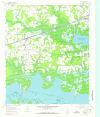
1955 Map of Maud
USGS Topo · Published 1978About this map
The town of Maud sits at the crossing of a light-duty road network and the St Louis Southwestern railroad, serving as a hub for the agricultural and timbered lands of southern Bowie County. This mid-century landscape is defined by the transformation of the Sulphur River valley following the creation of Wright Patman Lake, which has inundated much of the former bottomlands to form irregular shorelines and features like Mc Farland Island. To the northeast, the Red River Arsenal occupies a significant tract near Redwater, indicating the military's influence on local land use. Throughout the area, small community centers remain anchored by landmarks such as Friendship Ch and Oak Ridge Ch, alongside family-named sites like Harris Cem and Ridge Cem, which provide essential points of reference for genealogists tracing local families during this period of transition.
Find a feature on this map
21 named features on this map. Tap any name to fly to it.
Don’t see what you’re looking for? This feature index may not catch every label — zoom into the map to look around manually.
Map Details
Editions of this 1955 Maud Map

Other maps of this area

1907 · Atlanta
USGS Topo · 1:62,500

1909 · New Boston
USGS Topo · 1:62,500

1909 · Texarkana
USGS Topo · 1:62,500

1910 · Linden
USGS Topo · 1:62,500

1910 · Atlanta
USGS Topo · 1:62,500

1953 · Texarkana
USGS Topo · 1:250,000

1954 · New Boston
USGS Topo · 1:24,000

1954 · Leary
USGS Topo · 1:24,000

1954 · Hooks
USGS Topo · 1:24,000

1954 · Lake Texarkana
USGS Topo · 1:24,000