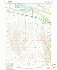
1970 Map of Maxwell SW
USGS Topo · Published 1983About this map
The North Platte River and South Platte River converge just west of this map, creating a complex hydrologic landscape defined by braided channels and fertile bottomlands. The Union Pacific railroad and the Fremont Slough parallel the river system, supporting the early transport and agricultural infrastructure of Lincoln County. Notable landmarks like Sioux Lookout and its Sioux Lookout Historical Mon rise above the Platte Valley, marking a point of historical significance on the high ground overlooking the Tri-County Supply Canal. Further south, the terrain shifts into the broken draws of Moran Canyon. Local educational and community sites, including the Mid-Plains Vocational-Technical College and rural institutions like the Pleasant View Sch and Miriam Cem, provide concrete points of reference for genealogists tracking family history in the rural Nebraska landscape.
Find a feature on this map
29 named features on this map. Tap any name to fly to it.
Don’t see what you’re looking for? This feature index may not catch every label — zoom into the map to look around manually.
Map Details
Editions of this 1970 Maxwell SW Map
2 editions found
Other maps of this area

1899 · North Platte
USGS Topo · 1:125,000

1902 · North Platte
USGS Topo · 1:125,000

1954 · McCook
USGS Topo · 1:250,000

1954 · North Platte
USGS Topo · 1:250,000

1956 · North Platte
USGS Topo · 1:250,000

1956 · Wellfleet NW
USGS Topo · 1:24,000

1956 · Wellfleet NE
USGS Topo · 1:24,000

1957 · North Platte
USGS Topo · 1:250,000

1957 · McCook
USGS Topo · 1:250,000

1958 · McCook
USGS Topo · 1:250,000