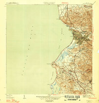
1947 Map of Mayaguez
USGS Topo · Published 1947About this map
Mayagüez and its surrounding sugar-producing hinterlands are detailed in this survey conducted during the late 1930s. The city's industrial and academic character is anchored by the Colegio de Agricultura y Artes Mecanicas and the U. S. Dept. of Agriculture Experiment Station, reflecting the era's focus on agricultural advancement. Along the coast, the American Railroad of Puerto Rico connects key points from Estación Playa to the sugar processing hub of Central Rochelaise.
Find a feature on this map
53 named features on this map. Tap any name to fly to it.
Don’t see what you’re looking for? This feature index may not catch every label — zoom into the map to look around manually.
Map Details
Editions of this 1947 Mayaguez Map
4 editions found
Other maps of this area

1935 · Puerto Real
USGS Topo · 1:25,000

1937 · San German
USGS Topo · 1:25,000

1937 · Puerto Real
USGS Topo · 1:25,000

1938 · Alto Sano
USGS Topo · 1:20,000

1939 · Mayaguez
USGS Topo · 1:30,000

1941 · Rincon
USGS Topo · 1:30,000

1941 · San German
USGS Topo · 1:30,000

1941 · Puerto Real
USGS Topo · 1:30,000

1941 · Rincon
USGS Topo · 1:30,000

1941 · Rosario
USGS Topo · 1:30,000