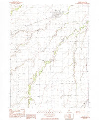
1983 Map of Mazon
USGS Topo · Published 1983About this map
Mazon sits at the convergence of the Atchison Topeka and Santa Fe railroad and the Mazon River, serving as a central hub for the surrounding agricultural townships of Goodfarm and Vienna. This landscape is defined by the winding paths of the West Fork Mazon River and Gooseberry Creek, which cut through the level prairie of Grand Ridge. Local history is deeply embedded in the rural landscape, from the smaller settlement of Verona on the western edge to the many family and community burial grounds like Goodfarm Cem and Wheeler Cem. The area’s infrastructure in the early 1980s supported a mix of traditional farming and modern transport, including the Icg railroad line and the Dwight Airport. Small-scale industry is evidenced by a Mine located along the Santa Fe tracks, while rural social life centered around landmarks such as Trinity Ch and the Goodfarm Sch.
Find a feature on this map
41 named features on this map. Tap any name to fly to it.
Don’t see what you’re looking for? This feature index may not catch every label — zoom into the map to look around manually.
Map Details
Editions of this 1983 Mazon Map
2 editions found
Other maps of this area

1892 · Morris
USGS Topo · 1:62,500

1892 · Marseilles
USGS Topo · 1:62,500

1916 · Marseilles
USGS Topo · 1:62,500

1918 · Morris
USGS Topo · 1:62,500

1940 · Marseilles
USGS Topo · 1:62,500

1948 · Dwight
USGS Topo · 1:62,500

1950 · Dwight
USGS Topo · 1:62,500

1953 · Morris
USGS Topo · 1:24,000

1953 · Coal City
USGS Topo · 1:24,000
1954 · Morris
USGS Topo · 1:62,500