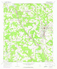
1964 Map of Mc Donough
USGS Topo · Published 1975About this map
McDonough serves as the focal point of this mid-century survey, situated at the intersection of several significant local arteries like Payetteville Road and Mt Carmel Road. The landscape is a network of rural homesteads and agricultural tracts, marked by numerous family-named landmarks and cemeteries such as Westmoreland Cem and Akins Cem. Small communities like Flippen to the north and Blacksville to the south are linked by the Southern railroad, which cuts a diagonal path through the terrain. Evidence of community life is visible in features like the Shingle Roof Campground and the Fairgrounds near the town center. The eastern edge of the map is defined by the drainage of Tussahaw Creek and the Iris Lakes, illustrating the transition from the developed town square to the more creek-crossed rural landscape of Henry County.
Find a feature on this map
57 named features on this map. Tap any name to fly to it.
Don’t see what you’re looking for? This feature index may not catch every label — zoom into the map to look around manually.
Map Details
Editions of this 1964 Mc Donough Map
4 editions found
Other maps of this area

1888 · Atlanta
USGS Topo · 1:125,000

1890 · Atlanta
USGS Topo · 1:125,000

1892 · Atlanta
USGS Topo · 1:125,000

1895 · Atlanta
USGS Topo · 1:125,000

1953 · Atlanta
USGS Topo · 1:250,000

1954 · Jonesboro
USGS Topo · 1:24,000

1957 · Atlanta
USGS Topo · 1:250,000

1958 · Atlanta
USGS Topo · 1:250,000

1964 · Luella
USGS Topo · 1:24,000
1964 · Mc Donough
USGS Topo · 1:24,000