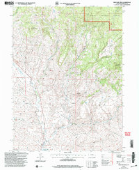
1971 Map of Mc Inturf Mesa
USGS Topo · Published 1985About this map
Mc Inturf Mesa and the high desert terrain of Moffat County dominate this landscape as it appeared at the turn of the 21st century. The map depicts a rugged transition from the Routt National Forest in the northeast to the sprawling drainages of Little Fortification Creek and Cottonwood Creek in the west. Local industry and resource extraction are marked by the Buckeye Mine and the curious designation of Dry Hole near the center of the sheet. High points like Pinnacle Mountain and Little Buck Mountain provide distinct landmarks for navigating the complex topography of ridges and draws, including Cote Gulch and Cedar Hill. Water remains a vital element of this arid environment, evidenced by the presence of Ralph White Lake and the various seasonal creeks that define the erosion patterns across the quadrangle.
Find a feature on this map
16 named features on this map. Tap any name to fly to it.
Don’t see what you’re looking for? This feature index may not catch every label — zoom into the map to look around manually.
Map Details
Editions of this 1971 Mc Inturf Mesa Map
4 editions found
Other maps of this area

1916 · Craig
USGS Topo · 1:125,000

1923 · Elkhead Creek
USGS Topo · 1:62,500

1924 · Elkhead Creek
USGS Topo · 1:62,500

1954 · Craig
USGS Topo · 1:250,000

1957 · Craig
USGS Topo · 1:250,000

1958 · Craig
USGS Topo · 1:250,000

1960 · Craig
USGS Topo · 1:250,000

1962 · Craig
USGS Topo · 1:250,000

1964 · Craig
USGS Topo · 1:250,000

1965 · Craig
USGS Topo · 1:250,000