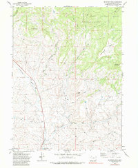
1971 Map of Mc Inturf Mesa
USGS Topo · Published 2000About this map
Mc Inturf Mesa and the prominent heights of Pinnacle Mountain define this high-country landscape in northwestern Colorado during the early 1970s. The terrain is deeply incised by the drainage systems of Fortification Creek and Little Bear Creek, reflecting a region shaped by both natural erosion and resource extraction. While much of the northeastern portion is protected within the Routt National Forest, the map also documents localized industrial activity through the presence of the Bridges Mine, Seymour Mine, and scattered drill holes. These features, along with the Tipton Trail and various jeep tracks, suggest a working landscape utilized for grazing, mining, and timber. The western edge is anchored by the waters of Ralph White Lake, providing a distinct contrast to the surrounding ridges like Little Buck Mountain and the sheltered slopes of Cedar Hill.
Find a feature on this map
20 named features on this map. Tap any name to fly to it.
Don’t see what you’re looking for? This feature index may not catch every label — zoom into the map to look around manually.
Map Details
Editions of this 1971 Mc Inturf Mesa Map
4 editions found
Other maps of this area

1916 · Craig
USGS Topo · 1:125,000

1923 · Elkhead Creek
USGS Topo · 1:62,500

1924 · Elkhead Creek
USGS Topo · 1:62,500

1954 · Craig
USGS Topo · 1:250,000

1957 · Craig
USGS Topo · 1:250,000

1958 · Craig
USGS Topo · 1:250,000

1960 · Craig
USGS Topo · 1:250,000

1962 · Craig
USGS Topo · 1:250,000

1964 · Craig
USGS Topo · 1:250,000

1965 · Craig
USGS Topo · 1:250,000