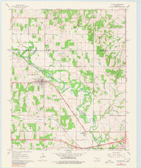
1966 Map of Mc Loud
USGS Topo · Published 1980About this map
Mc Loud serves as the central hub of this mid-1960s survey, situated along the Chicago Rock Island and Pacific railroad line. The landscape is defined by the winding course of the North Canadian River and its various tributaries, including Brush Creek and North Deer Creek. Local community life is rooted in sites like the Kickapoo Mission, Minneha Ch, and the Community Hall, while the industrial presence of the Mc Loud Gas Field and scattered Sandpits indicates the extraction economy of the era.
Find a feature on this map
34 named features on this map. Tap any name to fly to it.
Don’t see what you’re looking for? This feature index may not catch every label — zoom into the map to look around manually.
Map Details
Editions of this 1966 Mc Loud Map
3 editions found
Other maps of this area

1896 · Seminole and Prague
USGS Topo · 1:125,000

1898 · Purcell
USGS Topo · 1:125,000

1905 · Chandler
USGS Topo · 1:62,500

1907 · Chandler
USGS Topo · 1:62,500

1909 · Shawnee
USGS Topo · 1:62,500

1909 · Luther
USGS Topo · 1:62,500

1930 · McLoud
USGS Topo · 1:62,500

1954 · Oklahoma City
USGS Topo · 1:250,000

1956 · Harrah
USGS Topo · 1:24,000

1956 · Horseshoe Lake
USGS Topo · 1:24,000