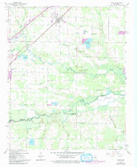
1963 Map of Mc Rae
USGS Topo · Published 1993About this map
The Missouri Pacific corridor dictates the rhythm of life in this corner of Arkansas, connecting the growing hubs of Beebe and McRae along a straight north-south axis. Between these settlements, the landscape transitions from established towns to the intricate water systems of the lowlands. The survey reveals a region defined by its hydrology, where Bull Creek and Cypress Bayou meander through the southern reaches, punctuated by localized features like Cobb Lake and Cheek Lake. Genealogists will find significant value in the distribution of family and community landmarks, such as Harrison Chapel and Gyles Cem, which are tucked away from the main transit lines. The area's agricultural and environmental character is further evidenced by several large Fish Hatchery sites, while the boundary lines of White and Lonoke counties meet at the winding course of the bayou, reflecting how natural terrain shaped administrative borders.
Find a feature on this map
36 named features on this map. Tap any name to fly to it.
Don’t see what you’re looking for? This feature index may not catch every label — zoom into the map to look around manually.
Map Details
Editions of this 1963 Mc Rae Map
3 editions found
Other maps of this area

1932 · Kensett
USGS Topo · 1:62,500

1935 · Kensett
USGS Topo · 1:62,500

1935 · Hazen
USGS Topo · 1:62,500

1940 · Lonoke
USGS Topo · 1:62,500

1941 · Hazen
USGS Topo · 1:62,500

1948 · Helena
USGS Topo · 1:250,000

1949 · Lonoke
USGS Topo · 1:62,500

1950 · Helena
USGS Topo · 1:250,000

1950 · Lonoke
USGS Topo · 1:62,500

1953 · Memphis
USGS Topo · 1:250,000