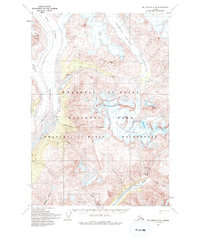
1959 Map of McCarthy C-4
USGS Topo · Published 1994About this map
The glacial systems of Rohn Glacier, Frederika Glacier, and Regal Glacier dominate this mid-century survey of the Alaskan interior. The landscape is defined by the convergence of the Nizina River and the Chitistone River, where dramatic elevation changes are marked by the Chitistone Falls and the deep Chitistone Gorge. Evidence of human presence is minimal in this wilderness, represented by a single Cabin and a sparse Trail network, suggesting a period of limited exploration and seasonal use.
Find a feature on this map
26 named features on this map. Tap any name to fly to it.
Don’t see what you’re looking for? This feature index may not catch every label — zoom into the map to look around manually.
Map Details
Editions of this 1959 McCarthy C-4 Map
3 editions found
Other maps of this area

1951 · McCarthy
USGS Topo · 1:250,000

1959 · McCarthy C-5
USGS Topo · 1:63,360

1959 · McCarthy B-5
USGS Topo · 1:63,360

1959 · McCarthy C-4
USGS Topo · 1:63,360

1959 · McCarthy B-4
USGS Topo · 1:63,360

1959 · McCarthy D-3
USGS Topo · 1:63,360

1959 · McCarthy C-3
USGS Topo · 1:63,360

1959 · McCarthy B-3
USGS Topo · 1:63,360
1960 · McCarthy D-5
USGS Topo · 1:63,360

1960 · McCarthy D-4
USGS Topo · 1:63,360