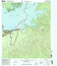
2003 Map of McGee Bend
USGS Topo · Published 2004About this map
The Sam Rayburn Reservoir dominates this East Texas landscape, where the waters of the Angelina River are contained by the engineering of the McGee Bend Dam. This 2003 revision, based on earlier topographic data, illustrates the recreational and infrastructure development along the shores of the Angelina National Forest. Public lands managed by the Forest Service and the Corps of Engineers are clearly delineated, featuring a network of facilities including Ebenezer Park (COE) and Twin Dikes Park (COE) with their associated docks and boat ramps.
Find a feature on this map
38 named features on this map. Tap any name to fly to it.
Don’t see what you’re looking for? This feature index may not catch every label — zoom into the map to look around manually.
Map Details
Editions of this 2003 McGee Bend Map
This is the sole edition of this map. No revisions or reprints were ever made.
Other maps of this area

1952 · Lake Charles
USGS Topo · 1:250,000

1953 · Alexandria
USGS Topo · 1:250,000

1953 · Palestine
USGS Topo · 1:250,000

1954 · Lake Charles
USGS Topo · 1:250,000

1954 · Beaumont
USGS Topo · 1:250,000

1955 · Alexandria
USGS Topo · 1:250,000

1955 · Roganville
USGS Topo · 1:62,500

1955 · Curtis
USGS Topo · 1:62,500

1957 · Beaumont
USGS Topo · 1:250,000

1957 · Palestine
USGS Topo · 1:250,000